Voh | |
|---|---|
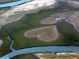
 A view of the Heart of Voh | |
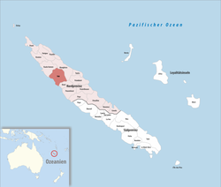
 Location of the commune (in red) within New Caledonia | |
| Coordinates: 20°57′33″S 164°41′17″E / 20.9593°S 164.688°E | |
| Country | France |
| Sui generis collectivity | New Caledonia |
| Province | North Province |
| Government | |
| • Mayor (2020–2026) | Joel Boatate Kolekole[1] |
| Area 1 | 804.9 km2 (310.8 sq mi) |
| Population (2019 census)[2] | 2,856 |
| • Density | 3.5/km2 (9.2/sq mi) |
| Ethnic distribution | |
| • 2019 census | Kanaks 63.45% Europeans 8.65% Wallisians and Futunans 1.58% Mixed 13.1% Other 13.24% |
| Time zone | UTC+11:00 |
| INSEE/Postal code | 98831 /98833 |
| Elevation | 0–1,122 m (0–3,681 ft) (avg. 6 m or 20 ft) |
| 1 New Caledonia Land Register (DITTT) data, which exclude lakes and ponds larger than 1 km² (0.386 sq mi or 247 acres) as well as the estuaries of rivers. | |
Voh (French pronunciation: [vo]) is a commune in the North Province of New Caledonia, an overseas territory of France in the Pacific Ocean.
It has become famous for the aerial photography of what is known as The Heart of Voh, a large formation of vegetation that resembles a heart seen from above. Photographer Yann Arthus-Bertrand contributed to its popularity by using a photograph of the 'heart' as the dust jacket art to his books The Earth from the Air[3] and Earth from Above.[4]
Voh is also the closest large settlement to the enormous Koniambo mine, and it hosted indentured Vietnamese mineworkers from the late 1800s until the 1940s, termed the Chân Dăng.
- ^ "Répertoire national des élus: les maires" (in French). data.gouv.fr, Plateforme ouverte des données publiques françaises. 4 May 2022.
- ^ Population, ménages et logement par commune, en 2019, Institut de la statistique et des études économiques Nouvelle-Calédonie
- ^ Arthus-Bertrand, Yann (1999-10-25). The Earth from the Air. Thames & Hudson Ltd. ISBN 0-500-01955-X.
- ^ Arthus-Bertrand, Yann (August 2002). Earth from Above. HNA Books. ISBN 0-8109-3495-7.
