This article has multiple issues. Please help improve it or discuss these issues on the talk page. (Learn how and when to remove these messages)
|
Voiron | |
|---|---|
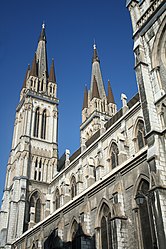
 Church of Saint-Bruno de Voiron | |
| Coordinates: 45°21′51″N 5°35′26″E / 45.3642°N 5.5906°E | |
| Country | France |
| Region | Auvergne-Rhône-Alpes |
| Department | Isère |
| Arrondissement | Grenoble |
| Canton | Voiron |
| Intercommunality | Pays Voironnais |
| Government | |
| • Mayor (2020–2026) | Julien Polat[1] |
Area 1 | 21.9 km2 (8.5 sq mi) |
| Population (2021)[2] | 20,891 |
| • Density | 950/km2 (2,500/sq mi) |
| Time zone | UTC+01:00 (CET) |
| • Summer (DST) | UTC+02:00 (CEST) |
| INSEE/Postal code | 38563 /38500 |
| Elevation | 222–846 m (728–2,776 ft) (avg. 290 m or 950 ft) |
| 1 French Land Register data, which excludes lakes, ponds, glaciers > 1 km2 (0.386 sq mi or 247 acres) and river estuaries. | |
Voiron (French pronunciation: [vwaʁɔ̃]; Arpitan: Vouèron) is a commune (French municipality) in the Isère department in southeastern France.[3] It is the capital of the canton of Voiron and has been part of the Grenoble-Alpes Métropole since 2010. Voiron is located 25 km (16 mi) northwest of Grenoble and 85 km (53 mi) southeast of Lyon. Its roughly 20,000 inhabitants are named Voironnais in French.
Voiron, along with Chambéry and Grenoble, is a gateway city of the Chartreuse Mountains in the Auvergne-Rhône-Alpes region.
- ^ "Répertoire national des élus: les maires". data.gouv.fr, Plateforme ouverte des données publiques françaises (in French). 2 December 2020.
- ^ "Populations légales 2021" (in French). The National Institute of Statistics and Economic Studies. 28 December 2023.
- ^ INSEE commune file


