| Volkhov | |
|---|---|
 | |
 | |
| Native name | Волхов (Russian) |
| Location | |
| Country | Russia |
| Region | Novgorod Oblast, Leningrad Oblast |
| Cities | Veliky Novgorod, Kirishi, Volkhov, Novaya Ladoga |
| Physical characteristics | |
| Source | Lake Ilmen |
| • coordinates | 58°28′N 31°17′E / 58.467°N 31.283°E |
| • elevation | 18 m (59 ft) |
| Mouth | Lake Ladoga |
• coordinates | 60°07′N 32°19′E / 60.117°N 32.317°E |
• elevation | 5 m (16 ft) |
| Length | 224 km (139 mi) |
| Basin size | 80,200 km2 (31,000 sq mi) |
| Discharge | |
| • location | mouth |
| • average | 580 m3/s (20,000 cu ft/s) |
| • minimum | 44 m3/s (1,600 cu ft/s) |
| • maximum | 2,900 m3/s (100,000 cu ft/s) |
| Basin features | |
| Progression | Lake Ladoga→ Neva→ Gulf of Finland |
| Tributaries | |
| • left | Tigoda |
| • right | Vishera, Oskuya, Pchyovzha |

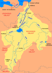
The Volkhov (/ˈvɔːlxɒv/ VAWL-khov; Russian: Волхов [ˈvoɫxəf]; Veps: Olhav) is a river in Novgorodsky and Chudovsky Districts of Novgorod Oblast and Kirishsky and Volkhovsky Districts of Leningrad Oblast in northwestern Russia. The Volkhov, which forms part of the basin of the Neva, is the only outflow of Lake Ilmen, and connects it with Lake Ladoga. The length of the Volkhov is 224 kilometres (139 mi),[1] and the area of its drainage basin is 80,200 square kilometres (31,000 sq mi).[1] The city of Veliky Novgorod, the towns of Kirishi, Volkhov and Novaya Ladoga, and the historically important village of Staraya Ladoga are located along the Volkhov.
- ^ a b "Body of water in the State Water Register of Russia". textual.ru (in Russian).