Vries | |
|---|---|
Village | |
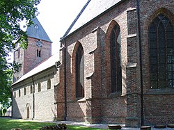
 Romaanse Sint-Bonifatiuskerk van Vries | |
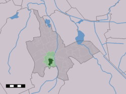
 The village centre (dark green) and the statistical district (light green) of Vries in the municipality of Tynaarlo. | |
| Coordinates: 53°4′24″N 6°34′37″E / 53.07333°N 6.57694°E | |
| Country | Netherlands |
| Province | Drenthe |
| Municipality | Tynaarlo |
| Area | |
• Total | 10.40 km2 (4.02 sq mi) |
| Elevation | 7 m (23 ft) |
| Population (2021)[1] | |
• Total | 4,045 |
| • Density | 390/km2 (1,000/sq mi) |
| Time zone | UTC+1 (CET) |
| • Summer (DST) | UTC+2 (CEST) |
| Postal code | 9481[1] |
| Dialing code | 0592 |
Vries is a village in the Dutch province of Drenthe. It is a part of the municipality of Tynaarlo, and lies about 8 km north of Assen.
Vries was a separate municipality until 1998, when it was merged with Eelde and Zuidlaren into a new municipality called Tynaarlo.[3]
- ^ a b c "Kerncijfers wijken en buurten 2021". Central Bureau of Statistics. Retrieved 12 April 2022.
- ^ "Postcodetool for 9481AA". Actueel Hoogtebestand Nederland (in Dutch). Het Waterschapshuis. 24 July 2019. Retrieved 12 April 2022.
- ^ Ad van der Meer and Onno Boonstra, "Repertorium van Nederlandse gemeenten", KNAW, 2006."KNAW > Publicaties > Detailpagina". Archived from the original on February 20, 2007. Retrieved December 3, 2009.


