Vryheid | |
|---|---|
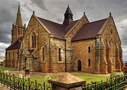
 Dutch Reformed Church on Church Square. | |
| Coordinates: 27°46′01″S 30°48′00″E / 27.76694°S 30.80000°E | |
| Country | South Africa |
| Province | KwaZulu-Natal |
| District | Zululand |
| Municipality | Abaqulusi |
| Established | 1884[1] |
| Area | |
| • Total | 48.71 km2 (18.81 sq mi) |
| Population (2011)[2] | |
| • Total | 47,365 |
| • Density | 970/km2 (2,500/sq mi) |
| Racial makeup (2011) | |
| • Black African | 84.5% |
| • Coloured | 1.7% |
| • Indian/Asian | 1.3% |
| • White | 12.1% |
| • Other | 0.3% |
| First languages (2011) | |
| • Zulu | 79.8% |
| • Afrikaans | 10.2% |
| • English | 6.2% |
| • Other | 3.7% |
| Time zone | UTC+2 (SAST) |
| Postal code (street) | 3100 |
| PO box | 3100 |
| Area code | 034 |
Vryheid (Zulu: eFilidi/iFilidiAbaqulusi) is a coal mining and cattle ranching town in northern KwaZulu-Natal, South Africa. Vryheid is the Afrikaans word for "freedom", while its original name of Abaqulusi reflects the abaQulusi clan based in the local area.[3]
- ^ Robson, Linda Gillian (2011). "Annexure A" (PDF). The Royal Engineers and settlement planning in the Cape Colony 1806–1872: Approach, methodology and impact (PhD thesis). University of Pretoria. pp. xlv–lii. hdl:2263/26503.
- ^ a b c d "Main Place Vryheid". Census 2011.
- ^ "AbaQulusi Local Municipality - Contact Details".

