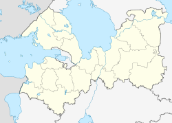
Vsevolozhsk
Всеволожск | |
|---|---|
 Vsevolozhsk as seen from the sixteenth floor of an apartment building | |
| Coordinates: 60°02′N 30°40′E / 60.033°N 30.667°E | |
| Country | Russia |
| Federal subject | Leningrad Oblast[1] |
| Administrative district | Vsevolozhsky District[1] |
| Settlement municipal formation | Vsevolozhskoye Settlement Municipal Formation[1] |
| Founded | 1892 |
| Elevation | 30 m (100 ft) |
| Population | |
| • Total | 59,704 |
| • Rank | 275th in 2010 |
| • Capital of | Vsevolozhsky District,[1] Vsevolozhskoye Settlement Municipal Formation[1] |
| • Municipal district | Vsevolozhsky Municipal District[3] |
| • Urban settlement | Vsevolozhskoye Urban Settlement[3] |
| • Capital of | Vsevolozhsky Municipal District,[3] Vsevolozhskoye Urban Settlement[3] |
| Time zone | UTC+3 (MSK |
| Postal code(s)[5] | 188640–188645, 188649, 188699 |
| OKTMO ID | 41612101001 |
| Website | www |
Vsevolozhsk (Russian: Все́воложск, IPA: [ˈfsʲevələʂsk]; Finnish: Seuloskoi) is a town and the administrative center of Vsevolozhsky District in Leningrad Oblast, Russia, located on the Karelian Isthmus 24 kilometers (15 mi) east of St. Petersburg. Population: 59,704 (2010 Census);[2] 45,310 (2002 Census);[6] 31,946 (1989 Soviet census).[7]
| Year | Pop. | ±% |
|---|---|---|
| 1926 | 1,324 | — |
| 1939 | 11,848 | +794.9% |
| 1959 | 27,768 | +134.4% |
| 1970 | 26,978 | −2.8% |
| 1979 | 28,588 | +6.0% |
| 1989 | 31,946 | +11.7% |
| 2002 | 45,310 | +41.8% |
| 2010 | 59,704 | +31.8% |
| 2021 | 79,038 | +32.4% |
| Source: Census data | ||
The town's name comes from manufacturer Vsevolozhsky. In 1941–1944, the vital road connecting besieged Leningrad with the rest of Soviet Union, the Road of Life, passed through the town. Currently, a considerable part of the population of Vsevolozhsk commutes to St. Petersburg for work, which is facilitated by the wide-scale construction of apartment buildings in the town.
- ^ a b c d e f Cite error: The named reference
LeningradO_admwas invoked but never defined (see the help page). - ^ a b Russian Federal State Statistics Service (2011). Всероссийская перепись населения 2010 года. Том 1 [2010 All-Russian Population Census, vol. 1]. Всероссийская перепись населения 2010 года [2010 All-Russia Population Census] (in Russian). Federal State Statistics Service.
- ^ a b c d Cite error: The named reference
LeningradOVsevolozhskyD_munwas invoked but never defined (see the help page). - ^ "Об исчислении времени". Официальный интернет-портал правовой информации (in Russian). June 3, 2011. Retrieved January 19, 2019.
- ^ Почта России. Информационно-вычислительный центр ОАСУ РПО. (Russian Post). Поиск объектов почтовой связи (Postal Objects Search) (in Russian)
- ^ Federal State Statistics Service (May 21, 2004). Численность населения России, субъектов Российской Федерации в составе федеральных округов, районов, городских поселений, сельских населённых пунктов – районных центров и сельских населённых пунктов с населением 3 тысячи и более человек [Population of Russia, Its Federal Districts, Federal Subjects, Districts, Urban Localities, Rural Localities—Administrative Centers, and Rural Localities with Population of Over 3,000] (XLS). Всероссийская перепись населения 2002 года [All-Russia Population Census of 2002] (in Russian).
- ^ Всесоюзная перепись населения 1989 г. Численность наличного населения союзных и автономных республик, автономных областей и округов, краёв, областей, районов, городских поселений и сёл-райцентров [All Union Population Census of 1989: Present Population of Union and Autonomous Republics, Autonomous Oblasts and Okrugs, Krais, Oblasts, Districts, Urban Settlements, and Villages Serving as District Administrative Centers]. Всесоюзная перепись населения 1989 года [All-Union Population Census of 1989] (in Russian). Институт демографии Национального исследовательского университета: Высшая школа экономики [Institute of Demography at the National Research University: Higher School of Economics]. 1989 – via Demoscope Weekly.


