| Vulture Mountains | |
|---|---|
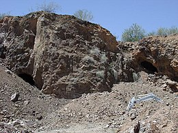
 Vulture Mountain and caves in the Vulture Mine area. | |
| Highest point | |
| Peak | Vulture Peak (Arizona) |
| Elevation | 3,658 ft (1,115 m) |
| Coordinates | 33°52′44″N 112°47′42″W / 33.87889°N 112.79500°W |
| Dimensions | |
| Length | 29 mi (47 km) E-W |
| Geography | |
| Country | United States |
| State | Arizona |
| Region | Sonoran Desert |
| County | Maricopa |
| Landmarks/rivers | Hassayampa River Preserve, Vulture Mine and Hassayampa River |
| Communities | Wickenburg, Aguila and Morristown |
| Range coordinates | 33°52′44″N 112°47′42″W / 33.87889°N 112.79500°W |
| Borders on | Harquahala Mountains, Aguila Valley, Wickenburg, Hassayampa River and Hassayampa Plain |
The Vulture Mountains is a 29-mile (47 km) long,[1] arid, low-elevation mountain range located in northwest Maricopa County, Arizona, United States. It is in the north perimeter region of the Sonoran Desert. The Arizona transition zone mountain ranges lie north and northeast, just north of Wickenburg, Arizona. The Yarnell Hill, about 14 miles (23 km) north of Wickenburg, rising into the Weaver Mountains to Yarnell, marks the dramatic elevation rise from the desert. It is also a viewpoint southwest and southeast of the desert regions, including the Vulture Mountains.
- ^ Utah DeLorme Atlas, p. 48.
