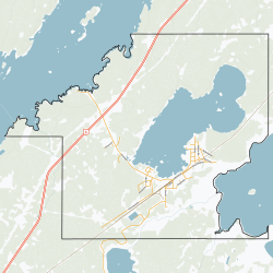
Wabowden | |
|---|---|
 Sign for Wabowden, Manitoba, Canada | |
 Boundaries | |
| Coordinates: 54°54′32″N 98°37′47″W / 54.90889°N 98.62972°W | |
| Country | Canada |
| Province | Manitoba |
| Region | Nor - Man |
| Government | |
| • MP | Niki Ashton |
| • MLA | Eric Redhead |
| Area | |
| • Total | 34.42 km2 (13.29 sq mi) |
| Population | |
| • Total | 442 |
| • Density | 12.8/km2 (33/sq mi) |
| Time zone | UTC−6 (CST) |
| • Summer (DST) | UTC−5 (CDT) |
| Postal code | R0B 1S0 |
| Area code | 204 |
| NTS Map | 063J15 |
| GNBC Code | GBCTE |
| Website | Community of Wabowden |
Wabowden is a community in northern Manitoba. It is situated on Provincial Trunk Highway No. 6, which is the main route between Thompson and the provincial capital, Winnipeg.
- ^ "Census Profile, 2016 Census". Statistics Canada, 2016 Census. April 14, 2017. Retrieved May 30, 2017.
