Wadi El Natrun
| |
|---|---|
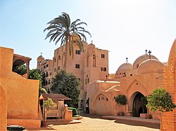
 Monastery of the Syriacs in Wadi el Natrun | |
| Coordinates: 30°35′N 30°20′E / 30.583°N 30.333°E | |
| Country | Egypt |
| Governorate | Beheira |
| Area | |
| • Total | 265.7 sq mi (688.2 km2) |
| Population (2021)[1] | |
| • Total | 88,380 |
| • Density | 330/sq mi (130/km2) |
| Time zone | UTC+2 (EET) |
Wadi El Natrun (Arabic: وادي النطرون "Valley of Natron"; Coptic: Ϣⲓϩⲏⲧ Šihēt, "measure of the hearts"[2]) is a depression in northern Egypt that is located 23 m (75 ft) below sea level and 38 m (125 ft) below the Nile River level. The valley contains several alkaline lakes, natron-rich salt deposits, salt marshes and freshwater marshes.[3]
In Christian literature it is usually known as Scetis (Σκήτις in Hellenistic Greek) or Skete (Σκήτη, plural Σκήτες in ecclesiastical Greek). It is one of the three early Christian monastic centers located in the Nitrian Desert of the northwestern Nile Delta.[4] The other two monastic centers are Nitria and Kellia.[4] Scetis, now called Wadi El Natrun, is best known today because its ancient monasteries remain in use, unlike Nitria and Kellia which have only archaeological remains.[4] The desertified valley around Scetis in particular may be called the Desert of Scetis.[5]
- ^ a b "Wadi an-Natrun (Markaz, Egypt) - Population Statistics, Charts, Map and Location". citypopulation.de. Retrieved 18 March 2023.
- ^ WĀDĪ NAṬRŪN in: Oxford Dictionary of Byzantium
- ^ Taher, A. G. (1999). "Inland saline lakes of Wadi el Natrun depression, Egypt". International Journal of Salt Lake Research. 8 (2): 149–169. doi:10.1007/BF02442128.
- ^ a b c Cite error: The named reference
bagnallwas invoked but never defined (see the help page). - ^ René-Georges Coquin (2005) [2002], "Scetis, Desert of", in André Vauchez (ed.), Encyclopedia of the Middle Ages, James Clarke & Co, ISBN 9780227679319.
