Wadi al Shatii
وادي الشاطئ | |
|---|---|
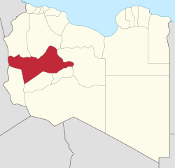
 Map of Libya with Wadi al Shatii district highlighted | |
| Country | Libya |
| Capital | Brak |
| Area | |
| • Total | 97,160 km2 (37,510 sq mi) |
| Population (2006) | |
| • Total | 78,532 |
| • Density | 0.81/km2 (2.1/sq mi) |
| [1] | |
| License Plate Code | 11, 55 |
Wadi al Shati (Arabic: وادي الشاطئ ), sometimes referred to as Ashati (Arabic: الشاطئ), is one of the districts of Libya in the central-west part of the country. The area is mostly desert. Wadi al Shati District is named after the depression (former lakebed) of the same name, Wadi Ashati.
To the west, Wadi al Shati borders the Illizi Province of Algeria. After the 2007 administrative reorganization of districts, it borders on Nalut in northwest, Jabal al Gharbi in the north, Jufra in the east, Sabha in the southeast, Wadi al Hayaa in the south and Ghat in the southwest.
- ^ "Districts of Libya". statoids.com. Retrieved 27 October 2009.