| Wagner Creek | |
|---|---|
 Wagner Creek watershed (Interactive map) | |
| Location | |
| Country | United States |
| Physical characteristics | |
| Source | |
| • location | West of County Road 2213 near Red Lick |
| • coordinates | 33°28′05″N 94°09′47″W / 33.468°N 94.163°W |
| Mouth | |
• location | Nash, Texas |
• coordinates | 33°27′50″N 94°07′11″W / 33.4640°N 94.1196°W |
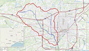
Wagner Creek is a creek in Bowie County, Texas.[1][2] The creek rises north of Nash and flows south-east, under several major highways including I-30, U.S. Route 82, I-369, before meeting Days Creek in southern Texarkana.[3]
Cowhorn Creek flows into the creek to the south of U.S. Route 67.[4]
- ^ Red River Below Denison Dam, Days Creek (AR,LA,OK,TX): Environmental Impact Statement. 1973.
- ^ Administration, United States Federal Insurance (1978). Flood Insurance Study: City of Texarkana, Texas, Bowie County. Department of Housing and Urban Development, Federal Insurance Administration.
- ^ Association, Texas State Historical. "Wagner Creek". Texas State Historical Association. Retrieved April 26, 2024.
- ^ Administration, United States Federal Insurance (1978). Flood Insurance Study: City of Texarkana, Texas, Bowie County. Department of Housing and Urban Development, Federal Insurance Administration.