Wahak Hotrontk, Arizona | |
|---|---|
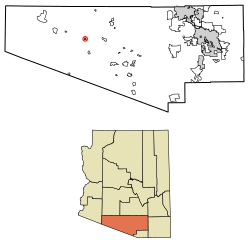
 Location of Wahak Hotrontk in Pima County, Arizona. | |
| Coordinates: 32°10′58″N 112°21′56″W / 32.18278°N 112.36556°W | |
| Country | United States |
| State | Arizona |
| County | Pima |
| Area | |
| • Total | 1.54 sq mi (3.99 km2) |
| • Land | 1.54 sq mi (3.99 km2) |
| • Water | 0.00 sq mi (0.00 km2) |
| Elevation | 1,939 ft (591 m) |
| Population (2020) | |
| • Total | 88 |
| • Density | 57.11/sq mi (22.05/km2) |
| Time zone | UTC-7 (Mountain (MST)) |
| ZIP code | 85634[2] |
| Area code | 520 |
| GNIS feature ID | 13276 |
Wahak Hotrontk also known as San Simon (O'odham) name translates as "Road Dips", is a census-designated place in Pima County, in the U.S. state of Arizona.[3][4] The population was 120 as of the 2020 census.[5] It is located along Arizona State Route 86 on the Tohono O'odham Nation reservation.
- ^ "2020 U.S. Gazetteer Files". United States Census Bureau. Retrieved October 29, 2021.
- ^ "Wahak Hotrontk AZ ZIP Code". zipdatamaps.com. 2023. Retrieved May 3, 2023.
- ^ Bright, William (2013). Native American Placenames of the United States. University of Oklahoma Press. p. 119. ISBN 978-0806124445.
- ^ "Wahak Hotrontk". Geographic Names Information System. United States Geological Survey, United States Department of the Interior.
- ^ "2010 Census Gazetteer Files – Places: Arizona". U.S. Census Bureau. Retrieved February 26, 2017.
