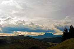
Waiapu Valley
| |
|---|---|
 Waiapu Valley, with Mount Hikurangi in the centre right of the picture. | |
 | |
| Coordinates: 37°59′S 178°7′E / 37.983°S 178.117°E | |
| Country | New Zealand |
| Region | Gisborne Region |
| Electorate | East Coast |
| Government | |
| • MP | Kiri Allan (Labour) |
| • Mayor | Rehette Stoltz |
| Population | |
| • Estimate (2002) | 2,000 |
| Time zone | UTC+12 (NZST) |
| • Summer (DST) | UTC+13 (NZDT) |
| Area code | 06 |
Waiapu Valley, also known as the Waiapu catchment, Waiapu River valley or simply Waiapu, is a valley in the north of the Gisborne Region on the East Coast of the North Island of New Zealand. It is the catchment area for the Waiapu River and its tributaries, and covers 1,734 square kilometres (670 sq mi).[2] The Raukumara Range forms the western side of the valley, with Mount Hikurangi in the central west. The towns of Ruatoria and Tikitiki are in the north-east of the valley.
The vast majority of the catchment area lies within the Waiapu and Matakaoa wards of the Gisborne District Council, with the southernmost area in the Waikohu and Uawa wards.[2][3] Some of the most Western points fall within the Coast Ward of the Opotiki District Council in the Bay of Plenty Region.[2][4]
The area is of immense cultural, spiritual, economic, and traditional significance to the local iwi, Ngāti Porou, and in 2002 approximately 90% of its 2,000 inhabitants were Māori.[1][2][5]
- ^ a b "Deed of Settlement Schedule: Documents" (PDF). Ngāti Porou Deed of Settlement. Wellington, New Zealand: New Zealand Government. 22 December 2010. p. 1. Retrieved 3 May 2012.
- ^ a b c d e Harmsworth, Garth; Warmenhoven, Tui Aroha (2002). "The Waiapu project: Maori community goals for enhancing ecosystem health". Hamilton, New Zealand: New Zealand Association of Resource Management. Archived from the original (DOC) on 18 December 2011. Retrieved 28 April 2012.
- ^ "Gisborne District Ward Map" (PDF). Gisborne, New Zealand: Gisborne District Council. Retrieved 27 April 2012.
- ^ "Map of the district" (JPG). Opotiki, New Zealand: Opotiki District Council. Retrieved 4 May 2012.
- ^ Reedy, Tamati Muturangi (4 March 2009). "Ngāti Porou - Tribal boundaries and resources". Te Ara - the Encyclopedia of New Zealand. Wellington, New Zealand: Manatū Taonga | Ministry for Culture and Heritage. Retrieved 3 May 2012.
