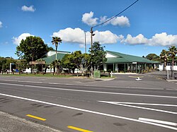
Waimauku | |
|---|---|
 Waimauku School | |
 | |
| Coordinates: 36°46′7″S 174°29′36″E / 36.76861°S 174.49333°E | |
| Country | New Zealand |
| Region | Auckland |
| Ward | Rodney ward |
| Community board | Rodney Local Board |
| Subdivision | Kumeū subdivision |
| Electorates | |
| Government | |
| • Territorial Authority | Auckland Council |
| Area | |
• Total | 1.44 km2 (0.56 sq mi) |
| Population (June 2024)[2] | |
• Total | 1,320 |
| • Density | 920/km2 (2,400/sq mi) |
Waimauku is a small locality in the Auckland Region of New Zealand. It comes under the jurisdiction of Auckland Council, and is in the council's Rodney ward. Waimauku is approximately 4 kilometres west of Huapai on State Highway 16 at the junction with the road to Muriwai Beach. Helensville is 16 km to the north-west.[3][4] Waimauku is a Māori word which is literally translated as wai: stream and mauku: varieties of small ferns.[5]
Formerly a farming and fruit-growing community, the area around Waimauku now features a number of wineries and an increasing suburban and lifestyle farming population.
The Auckland Regional Council announced in 2007 that Western Line rail services would be extended to Helensville for a one-year trial period commencing in July 2008.[6] This service would include a stop at Waimauku.[7] A new station platform was built at Waimauku and the service commenced on 14 July 2008.[8] The service ceased in 2009, and the platform is currently unused.[9]
- ^ Cite error: The named reference
Areawas invoked but never defined (see the help page). - ^ "Aotearoa Data Explorer". Statistics New Zealand. Retrieved 26 October 2024.
- ^ Peter Dowling, ed. (2004). Reed New Zealand Atlas. Reed Books. map 11. ISBN 0-7900-0952-8.
- ^ Roger Smith, GeographX (2005). The Geographic Atlas of New Zealand. Robbie Burton. map 34. ISBN 1-877333-20-4.
- ^ Wises New Zealand Guide, 7th Edition 1979. p.475
- ^ Auckland Regional Council Summary Draft Plan 2008/2009
- ^ "Commuter train services to resume to Helensville". The New Zealand Herald. 27 June 2007.
- ^ Dearnaley, Mathew (14 July 2008). "New commuter train services". The New Zealand Herald. Retrieved 14 July 2008.
- ^ "Calls for rail to ease congestion in Auckland's north-west". Stuff. 27 September 2016. Retrieved 11 November 2018.