| Wakerley Brisbane, Queensland | |||||||||||||||
|---|---|---|---|---|---|---|---|---|---|---|---|---|---|---|---|
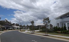
 Watervale Parade, 2014 | |||||||||||||||
 | |||||||||||||||
| Coordinates | 27°28′54″S 153°09′33″E / 27.4816°S 153.1591°E | ||||||||||||||
| Population | 8,718 (2021 census)[1] | ||||||||||||||
| • Density | 1,779/km2 (4,610/sq mi) | ||||||||||||||
| Postcode(s) | 4154 | ||||||||||||||
| Area | 4.9 km2 (1.9 sq mi) | ||||||||||||||
| Time zone | AEST (UTC+10:00) | ||||||||||||||
| Location | 17.7 km (11 mi) E of Brisbane CBD | ||||||||||||||
| LGA(s) | City of Brisbane (Chandler Ward;[2] Doboy Ward)[3] | ||||||||||||||
| State electorate(s) | Chatsworth | ||||||||||||||
| Federal division(s) | Bonner | ||||||||||||||
| |||||||||||||||
Wakerley is an eastern suburb in the City of Brisbane, Queensland, Australia.[4] In the 2021 census, Wakerley had a population of 8,718 people.[1]
- ^ a b Cite error: The named reference
Census2021was invoked but never defined (see the help page). - ^ "Chandler Ward". Brisbane City Council. Archived from the original on 4 February 2017. Retrieved 12 March 2017.
- ^ "Doboy Ward". Brisbane City Council. Archived from the original on 14 June 2018. Retrieved 12 March 2017.
- ^ "Wakerley – suburb in City of Brisbane (entry 49639)". Queensland Place Names. Queensland Government. Retrieved 11 October 2020.
