| Walker River Againahukwa (Northern Paiute) | |
|---|---|
 West Walker River near Leavitt Meadows | |
 Walker River and Walker Lake | |
| Native name | Againahukwa[1] (Northern Paiute) |
| Location | |
| Country | United States |
| State | Nevada |
| Cities | Yerington, Mason, Wabuska |
| Physical characteristics | |
| Source | West Walker River |
| • location | Sierra Nevada, California |
| • coordinates | 38°08′24″N 119°30′28″W / 38.14000°N 119.50778°W[2] |
| • elevation | 9,640 ft (2,940 m) |
| 2nd source | East Walker River |
| • location | Bridgeport Valley, California |
| • coordinates | 38°11′44″N 119°17′09″W / 38.19556°N 119.28583°W[3] |
| • elevation | 6,570 ft (2,000 m) |
| Source confluence | |
| • location | Yerington, Lyon County, Nevada |
| • coordinates | 38°53′35″N 119°10′44″W / 38.89306°N 119.17889°W[4] |
| • elevation | 4,442 ft (1,354 m) |
| Mouth | Walker Lake |
• location | Mineral County, Nevada |
• coordinates | 38°48′56″N 118°44′40″W / 38.81556°N 118.74444°W[4] |
• elevation | 3,973 ft (1,211 m) |
| Length | 62 mi (100 km) |
| Basin size | 3,134 sq mi (8,120 km2) |
| Discharge | |
| • location | Wabuska, NV |
| • average | 164 cu ft/s (4.6 m3/s) |
| • minimum | 0 cu ft/s (0 m3/s) |
| • maximum | 3,280 cu ft/s (93 m3/s) |
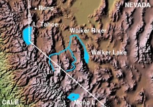
The Walker River is a river in west-central Nevada in the United States, approximately 62 miles (100 km) long. Fed principally by snowmelt from the Sierra Nevada of California, it drains an arid portion of the Great Basin southeast of Reno and flows into the endorheic basin of Walker Lake. The river is an important source of water for irrigation in its course through Nevada; water diversions have reduced its flow such that the level of Walker Lake has fallen 160 feet (49 m) between 1882 and 2010. The river was named for explorer Joseph Reddeford Walker, a mountain man and experienced scout who is known for establishing a segment of the California Trail.
- ^ Ginny Bengston (2002). Northern Paiute and Western Shoshone Land Use in Northern Nevada: A Class I Ethnographic/Ethnohistoric Overview (PDF). SWCA Environmental Consultants. p. 50. Retrieved 2022-12-30.
kuyuinahukwa.
- ^ U.S. Geological Survey Geographic Names Information System: West Walker River
- ^ U.S. Geological Survey Geographic Names Information System: East Walker River
- ^ a b U.S. Geological Survey Geographic Names Information System: Walker River