Walker Valley, New York | |
|---|---|
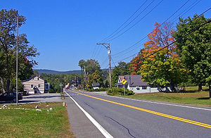
 Looking into Walker Valley from the east along NY 52 | |
 Location in Ulster County and the state of New York. | |
| Coordinates: 41°38′32″N 74°22′21″W / 41.64222°N 74.37250°W | |
| Country | United States |
| State | New York |
| County | Ulster |
| Area | |
| • Total | 3.25 sq mi (8.41 km2) |
| • Land | 3.24 sq mi (8.39 km2) |
| • Water | 0.01 sq mi (0.03 km2) |
| Elevation | 663 ft (202 m) |
| Population (2020) | |
| • Total | 1,269 |
| • Density | 391.91/sq mi (151.33/km2) |
| Time zone | UTC-5 (Eastern (EST)) |
| • Summer (DST) | UTC-4 (EDT) |
| ZIP code | 12588 |
| Area code | 845 |
| FIPS code | 36-77948 |
| GNIS feature ID | 0973199 |
Walker Valley is a hamlet (and census-designated place) located in the western part of the Town of Shawangunk in Ulster County, New York, United States, generally thought of as coterminous with the 12588 ZIP code. The population was 1,269 at the 2020 census.[2]
Walker Valley is one of the three geographic sections of the town that local residents use (The other two are Wallkill and Pine Bush). It is centered on NY 52 in the western part of town, where it begins to slope up to the Shawangunk Ridge.
- ^ "ArcGIS REST Services Directory". United States Census Bureau. Retrieved September 20, 2022.
- ^ Bureau, US Census. "Search Results". The United States Census Bureau. Retrieved March 27, 2023.
{{cite web}}:|last=has generic name (help)