Walong | |
|---|---|
town | |
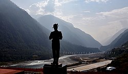
 Walong War Memorial | |
| Coordinates: 28°8′N 97°1′E / 28.133°N 97.017°E | |
| Country | |
| State | Arunachal Pradesh |
| District | Anjaw district |
| • Density | 13/km2 (30/sq mi) |
| Languages | |
| • Official | English |
| Time zone | UTC+5:30 (IST) |
| Nearest city | Tinsukia |
| Lok Sabha constituency | Arunachal East |
| Vidhan Sabha constituency | Hayuliang |
| Climate | Cwa |
Walong is an administrative town and the headquarters of eponymous circle in the Anjaw district in eastern-most part of Arunachal Pradesh state in India. It also has a small cantonment of the Indian Army. Walong is on banks of Lohit River, which enters India 35 km north of Walong at India-China LAC at Kaho pass.
Walong is also the easternmost town in mainland India. It is 20 km south of Kibithu, 60 km west of Diphu Pass (near India-China-Myanmar tri-junction), and 90 km north of district headquarter at Hawai. Anjaw district was carved out of Lohit District in 2004.
