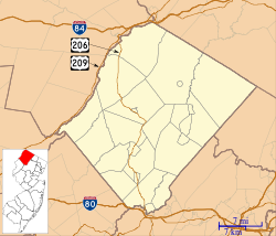
Walpack Township, New Jersey | |
|---|---|
 The downtown of Wallpack Center, New Jersey facing National Park Service Route 615 | |
| Motto: Oldest Municipality in Sussex County | |
 Location in Sussex County, New Jersey and of Sussex County in New Jersey (upper right) | |
 Census Bureau map of Walpack Township, New Jersey | |
Location of Walpack Township in Sussex County Location in New Jersey | |
| Coordinates: 41°07′16″N 74°53′24″W / 41.121°N 74.890°W[1][2] | |
| Country | |
| State | |
| County | |
| Earliest mention | October 26, 1731 |
| Incorporated | February 21, 1798 |
| Government | |
| • Type | Township |
| • Body | Township Committee |
| • Mayor | Victor J. Maglio (R, term ends December 31, 2024)[3][4] |
| • Municipal clerk | Christine M. Von Oesen[3] |
| Area | |
• Total | 24.88 sq mi (64.45 km2) |
| • Land | 24.24 sq mi (62.77 km2) |
| • Water | 0.65 sq mi (1.68 km2) 2.60% |
| • Rank | 109th of 565 in state 10th of 24 in county[1] |
| Elevation | 436 ft (133 m) |
| Population | |
• Total | 7 |
• Estimate (2023)[8] | 6 |
| • Rank | 565th of 565 in state 24th of 24 in county[9] |
| • Density | 0.3/sq mi (0.1/km2) |
| • Rank | 565th of 565 in state 24th of 24 in county[9] |
| Time zone | UTC−05:00 (Eastern (EST)) |
| • Summer (DST) | UTC−04:00 (Eastern (EDT)) |
| ZIP Code | 07881 – Walpack Center[10] |
| Area code | 908[11] |
| FIPS code | 3403776640[1][12][13] |
| GNIS feature ID | 0882259[1][14] |
| Website | www |
Walpack Township is a township in Sussex County, in the U.S. state of New Jersey. As of the 2020 United States census, the township's population was 7,[7] a decrease of 9 (−56.3%) from the 2010 census count of 16,[15][16] which in turn reflected a decline of 34 (−82.9%) from the 41 counted in the 2000 census.[17] Walpack Township was the smallest municipality by population and one of only four municipalities in New Jersey with a population under 100 as of the 2020 Census;[7] it had the state's third-smallest population in the 2010 census, behind Tavistock (population 5) and the now-defunct Pine Valley (population 12), both in Camden County.[18]
The township is named from a corruption of the Lenape Native American content word "wahlpeck," which means "turn-hole," or an eddy or whirlpool, a compound of two Native American words, "woa-lac" (a hole), and "tuppeck" (a pool),[19] though other sources attribute the name to mean "very deep water"[20] or "sudden bend of a stream around the base of a rock".[21]
- ^ a b c d e 2019 Census Gazetteer Files: New Jersey Places, United States Census Bureau. Accessed July 1, 2020.
- ^ US Gazetteer files: 2010, 2000, and 1990, United States Census Bureau. Accessed September 4, 2014.
- ^ a b Cite error: The named reference
Directorywas invoked but never defined (see the help page). - ^ 2023 New Jersey Mayors Directory, New Jersey Department of Community Affairs, updated April 1, 2024. Accessed April 1, 2024.
- ^ Cite error: The named reference
DataBookwas invoked but never defined (see the help page). - ^ U.S. Geological Survey Geographic Names Information System: Township of Walpack, Geographic Names Information System. Accessed March 14, 2013.
- ^ a b c Cite error: The named reference
LWD2020was invoked but never defined (see the help page). - ^ Cite error: The named reference
PopEstwas invoked but never defined (see the help page). - ^ a b Population Density by County and Municipality: New Jersey, 2020 and 2021, New Jersey Department of Labor and Workforce Development. Accessed March 1, 2023.
- ^ Look Up a ZIP Code for Walpack Center, NJ, United States Postal Service. Accessed February 26, 2013.
- ^ Area Code Lookup - NPA NXX for Walpack, NJ, Area-Codes.com. Accessed October 29, 2014.
- ^ U.S. Census website, United States Census Bureau. Accessed September 4, 2014.
- ^ Geographic Codes Lookup for New Jersey, Missouri Census Data Center. Accessed April 1, 2022.
- ^ US Board on Geographic Names, United States Geological Survey. Accessed September 4, 2014.
- ^ Cite error: The named reference
Census2010was invoked but never defined (see the help page). - ^ Cite error: The named reference
LWD2010was invoked but never defined (see the help page). - ^ Table 7. Population for the Counties and Municipalities in New Jersey: 1990, 2000 and 2010, New Jersey Department of Labor and Workforce Development, February 2011. Accessed May 1, 2023.
- ^ New Jersey: 2010 - Population and Housing Unit Counts - 2010 Census of Population and Housing (CPH-2-32), United States Census Bureau, August 2012. Accessed February 26, 2013.
- ^ Snell, James P. (1881) History of Sussex and Warren Counties, New Jersey, With Illustrations and Biographical Sketches of its Prominent Men and Pioneers. (Centennial ed., Harmony, NJ: Harmony Press, 1981), pgs. 314, 326.
- ^ Hutchinson, Viola L. The Origin of New Jersey Place Names, New Jersey Public Library Commission, May 1945. Accessed October 20, 2015.
- ^ Gannett, Henry. The Origin of Certain Place Names in the United States, p. 31. United States Government Printing Office, 1905. Accessed October 20, 2015.


