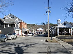
Walpole, New Hampshire | |
|---|---|
 Westminster Street in the center of Walpole | |
| Coordinates: 43°4′46″N 72°25′32″W / 43.07944°N 72.42556°W | |
| Country | United States |
| State | New Hampshire |
| County | Cheshire |
| Town | Walpole |
| Area | |
• Total | 1.23 sq mi (3.18 km2) |
| • Land | 1.22 sq mi (3.15 km2) |
| • Water | 0.01 sq mi (0.03 km2) |
| Elevation | 397 ft (121 m) |
| Population (2020) | |
• Total | 573 |
| • Density | 470.83/sq mi (181.77/km2) |
| Time zone | UTC-5 (Eastern (EST)) |
| • Summer (DST) | UTC-4 (EDT) |
| ZIP code | 03608 |
| Area code | 603 |
| FIPS code | 33-78340 |
| GNIS feature ID | 2629744 |
Walpole is a census-designated place (CDP) and the central village in the town of Walpole in Cheshire County, New Hampshire, United States. The population of the CDP was 573 at the 2020 census,[2] compared to 3,633 in the entire town.
- ^ "ArcGIS REST Services Directory". United States Census Bureau. Retrieved September 20, 2022.
- ^ "Walpole CDP, New Hampshire: 2020 DEC Redistricting Data (PL 94-171)". U.S. Census Bureau. Retrieved November 5, 2021.

