Walterboro, South Carolina | |
|---|---|
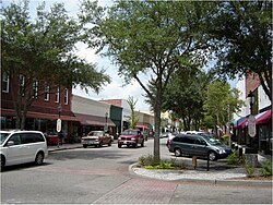
 East Washington Street in downtown Walterboro | |
| Motto: The Front Porch of the Lowcountry | |
 Location of Walterboro, South Carolina | |
| Coordinates: 32°54′15″N 80°39′58″W / 32.90417°N 80.66611°W | |
| Country | United States |
| State | South Carolina |
| County | Colleton |
| Area | |
| • Total | 6.84 sq mi (17.72 km2) |
| • Land | 6.84 sq mi (17.72 km2) |
| • Water | 0.00 sq mi (0.00 km2) |
| Elevation | 59 ft (18 m) |
| Population | |
| • Total | 5,544 |
| • Density | 810.05/sq mi (312.78/km2) |
| Time zone | UTC−5 (Eastern (EST)) |
| • Summer (DST) | UTC−4 (EDT) |
| ZIP code | 29488 |
| Area code(s) | 843, 854 |
| FIPS code | 45-74275[3] |
| GNIS feature ID | 1251318[4] |
| Website | www |
Walterboro is a city in Colleton County, South Carolina, United States. The city's population was 5,398 at the 2010 census.[5] It is the county seat of Colleton County.[6] Walterboro is located 48 miles (77 km) west of Charleston and is located near the ACE Basin region in the South Carolina Lowcountry.
- ^ "ArcGIS REST Services Directory". United States Census Bureau. Retrieved October 15, 2022.
- ^ Cite error: The named reference
USCensusDecennial2020CenPopScriptOnlywas invoked but never defined (see the help page). - ^ "U.S. Census website". United States Census Bureau. Retrieved January 31, 2008.
- ^ "US Board on Geographic Names". United States Geological Survey. October 25, 2007. Retrieved January 31, 2008.
- ^ "Geographic Identifiers: 2010 Census Summary File 1 (G001): Walterboro city, South Carolina". U.S. Census Bureau, American Factfinder. Archived from the original on February 13, 2020. Retrieved July 1, 2015.
- ^ "Find a County". National Association of Counties. Retrieved June 7, 2011.
