| Wamberal Central Coast, New South Wales | |||||||||||||||
|---|---|---|---|---|---|---|---|---|---|---|---|---|---|---|---|
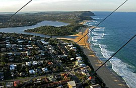
 Aerial view of Wamberal Beach | |||||||||||||||
 | |||||||||||||||
| Coordinates | 33°25′5″S 151°26′35″E / 33.41806°S 151.44306°E | ||||||||||||||
| Population | 6,298 (2011 census)[1] | ||||||||||||||
| • Density | 969/km2 (2,509/sq mi) | ||||||||||||||
| Postcode(s) | 2260 | ||||||||||||||
| Elevation | 11 m (36 ft) | ||||||||||||||
| Area | 6.5 km2 (2.5 sq mi) | ||||||||||||||
| Location |
| ||||||||||||||
| LGA(s) | Central Coast Council | ||||||||||||||
| Parish | Kincumber | ||||||||||||||
| State electorate(s) | Terrigal | ||||||||||||||
| Federal division(s) | Dobell | ||||||||||||||
| |||||||||||||||

Wamberal (/ˈwɒmbərəl/) is a coastal suburb of the Central Coast region of New South Wales, Australia, just north of Terrigal. It is part of the Central Coast Council local government area and is located adjacent to the Wamberal Lagoon. Wamberal is an Aboriginal word meaning 'where the sea breaks'.[2][3]
- ^ Australian Bureau of Statistics (31 October 2012). "Wamberal (SSC)". 2011 Census QuickStats. Retrieved 22 March 2013.
- ^ The Story of the Aboriginal People of the Central Coast of NSW by F.C. Bennett.
- ^ "Wamberal Street: Community History - Lake Macquarie Libraries". history.lakemac.com.au. Archived from the original on 12 April 2015.
