| Wambrook | |
|---|---|
 Wambrook, seen from the west | |
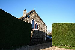
 Methodist Chapel | |
Location within Somerset | |
| Population | 184 (2011)[1] |
| OS grid reference | ST295075 |
| Civil parish |
|
| District | |
| Shire county | |
| Region | |
| Country | England |
| Sovereign state | United Kingdom |
| Post town | CHARD |
| Postcode district | TA20 |
| Dialling code | 01460 |
| Police | Avon and Somerset |
| Fire | Devon and Somerset |
| Ambulance | South Western |
| UK Parliament | |
Wambrook is a village and civil parish in the Blackdown Hills, Somerset, England. The village lies about 2 miles (3 km) southwest of the town of Chard. The parish includes the hamlets of Higher Wambrook and Lower Wambrook which is sometimes known as Haselcombe.
Ferne Animal Sanctuary is in the west of the parish.
- ^ "Statistics for Wards, LSOAs and Parishes — SUMMARY Profiles" (Excel). Somerset Intelligence. Retrieved 4 January 2014.
