| Pegunungan Wondiboy Nature Reserve | |
|---|---|
| Wondiboy Mountains Nature Reserve | |
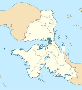
Location of the peninsula in West Papua Province | |
| Location | Teluk Wondama Regency, West Papua, Indonesia |
| Coordinates | 2°36′0″S 134°34′30″E / 2.60000°S 134.57500°E |
| Area | 795 km2 (307 sq mi) |
| Designation | Nature reserve |
| Governing body | Balai Besar Konservasi Sumber Daya Alam Papua Barat |
The Wondiboy Peninsula, also known as the Wondiwoi, Wandammen (spelled locally Wandamen), Wondama, or in old sources Mandamy[2][3] is a mountainous peninsula in Wondama Bay Regency, Western New Guinea. It extends northwards from the Bird's Neck Isthmus into Cenderawasih Bay, and is composed administratively of the Rasiei, Wondiboy, Wasior and Teluk Duairi Districts (kecamatan) within the regency. At the northern end of the peninsula the land breaks up into a series of islands which form Roon District, of which the largest is Roon Island.
Separate from the New Guinea Highlands, the mountain chain is northwest of the Kobowre Mountains summiting in Dogiyai Regency. These densely-forested mountains run north and south along the spine of the peninsula, rising from the shore up to 2,250 metres elevation, and extending southwards into the Bird's Neck Isthmus.[4] The eastern slope of the mountains is steeper than the western slope, and constitutes a thin coastal strip along the east coast of the peninsula which actually forms Teluk Umar District within Nabire Regency of Central Papua Province.
- ^ UNEP-WCMC (2024). Protected Area Profile for Pegunungan Wondiboy. World Database on Protected Areas. Retrieved 2 March 2024.
- ^ "Wondama". Wondama. Retrieved 2024-03-20.
- ^ "SEJARAH ASAL MUASAL NAMA WANDAMEN-WONDAMA". Manfasramdi. 2023-01-08. Retrieved 2024-03-20.
- ^ Diamond, Jared M. and Bishop, K. David. (2015). Avifaunas of the Kumawa and Fakfak Mountains, Indonesian New Guinea. Bulletin of the British Ornithologists' Club, Volume 135, Issue 4, 2015, pp. 292--336.

