You can help expand this article with text translated from the corresponding article in German. (September 2011) Click [show] for important translation instructions.
|
| Wandse Eilbek, Eilbekkanal | |
|---|---|
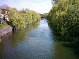
 Wandse as Eilbekkanal in Hamburg | |
 | |
| Location | |
| Country | Germany |
| States | |
| Physical characteristics | |
| Source | |
| • location | Siek |
| • coordinates | 53°38′26″N 10°16′46″E / 53.64056°N 10.27944°E |
| • elevation | 54 m (177 ft) |
| Mouth | Alster (Außenalster) |
• location | Hohenfelde, Hamburg |
• coordinates | 53°33′56″N 10°0′59″E / 53.56556°N 10.01639°E |
• elevation | 6 m (20 ft) |
| Length | 20 km (12 mi) |
| Discharge | |
| • average | 7.0 m3/s (250 cu ft/s) |
| Basin features | |
| Tributaries | |
| • left | Stellau, Rahlau |
| • right | Berner Au |
| Progression | Alster→ Elbe→ North Sea |
(in sections also called Eilbek) is a river flowing through Schleswig-Holstein and Hamburg, Germany.
The Wandse rises west of the village of Siek in Kreis Stormarn in Schleswig-Holstein and ends in the center of Hamburg in the Alster. Along the banks of the Wandse there were many water mills. The river passes through the settlements of Siek, Braak, Stapelfeld, and Hamburg.
The Hamburg district of Wandsbek takes its name from the river as it winds its way westwards via the Eichtal Park, a public urban park. After passing through the Mühlenteich pond, the river continues as Eilbek (later Eilbekkanal), eponymous to the Eilbek district. The canal joins the Alster in the heart of Hamburg at Außenalster.[1]
- ^ Theweleit, Klaus (1 June 1994). Object-choice: (All you need is love-- ) : on mating strategies & a fragment of a Freud biography. Verso. p. 102. ISBN 978-0-86091-642-0. Retrieved 15 September 2011.