Wanneperveen | |
|---|---|
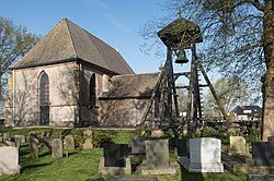
 Wanneperveen, reformed church with bell tower and consistory | |
| Coordinates: 52°42′12″N 6°07′25″E / 52.7032°N 6.1237°E | |
| Country | Netherlands |
| Province | Overijssel |
| Municipality | Steenwijkerland |
| Area | |
| • Total | 35.01 km2 (13.52 sq mi) |
| Elevation | 0 m (0 ft) |
| Population (2021)[1] | |
| • Total | 1,745 |
| • Density | 50/km2 (130/sq mi) |
| Time zone | UTC+1 (CET) |
| • Summer (DST) | UTC+2 (CEST) |
| Postal code | 7946[1] |
| Dialing code | 0522 |
Wanneperveen is a village in the Dutch province of Overijssel. It is located in the municipality of Steenwijkerland, about 4 km west of Meppel.
Wanneperveen was a separate municipality until 1973, when it became a part of Brederwiede.[3] In 2001 Brederwiede was merged with nearby Steenwijk to form Steenwijkerland
Wanneperveen and the land around it sit right on the edge of Overijssel in a small pocket of land and, as such, are no more than fifteen kilometres from the borders of Friesland, Drenthe and Flevoland.
- ^ a b c "Kerncijfers wijken en buurten 2021". Central Bureau of Statistics. Retrieved 17 March 2022.
- ^ "Postcodetool for 7946AA". Actueel Hoogtebestand Nederland (in Dutch). Het Waterschapshuis. Retrieved 17 March 2022.
- ^ Ad van der Meer and Onno Boonstra, Repertorium van Nederlandse gemeenten, KNAW, 2011.


