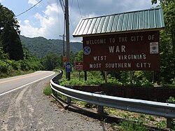
War, West Virginia | |
|---|---|
 | |
| Nickname: West Virginia's most southern city | |
 Location of War in McDowell County, West Virginia. | |
Location in the State of West Virginia | |
| Coordinates: 37°18′4″N 81°41′3″W / 37.30111°N 81.68417°W | |
| Country | United States |
| State | West Virginia |
| County | McDowell |
| Named for | War Creek |
| Government | |
| • Mayor | Thomas Hatcher[1] |
| Area | |
| • Total | 0.92 sq mi (2.38 km2) |
| • Land | 0.89 sq mi (2.31 km2) |
| • Water | 0.03 sq mi (0.08 km2) |
| Elevation | 1,342 ft (409 m) |
| Population | |
| • Total | 690 |
| • Estimate (2019)[3] | 662 |
| • Density | 768.80/sq mi (296.85/km2) |
| Time zone | UTC-5 (EST) |
| • Summer (DST) | UTC-4 (EDT) |
| ZIP code | 24892 |
| Area code | 304 |
| FIPS code | 54-84484[4] |
| GNIS feature ID | 1555916[5] |
| Website | local |
War is a city in McDowell County, West Virginia, United States. The population was 690 at the 2020 census.[3] War was incorporated in 1920 by the Circuit Court of McDowell County. Its name is derived from War Creek,[6] whose confluence with Dry Fork is located within the city. War is the only place in the United States with this name. War was formerly known as Miner's City.
- ^ "Elected Officials". State of West Virginia. Retrieved May 14, 2024.
- ^ "2019 U.S. Gazetteer Files". United States Census Bureau. Retrieved August 7, 2020.
- ^ a b c "City and Town Population Totals: 2020-2021". Census.gov. US Census Bureau. Retrieved July 3, 2022.
- ^ "U.S. Census website". United States Census Bureau. Retrieved January 31, 2008.
- ^ U.S. Geological Survey Geographic Names Information System: War, West Virginia
- ^ Capace, Nancy (1999). Encyclopedia of West Virginia. North American Book Dist LLC. p. 195. ISBN 978-0-403-09843-9.
