| Waratah Newcastle, New South Wales | |||||||||||||||
|---|---|---|---|---|---|---|---|---|---|---|---|---|---|---|---|
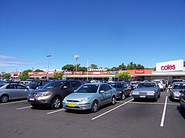
 Waratah Village Shopping Centre in March 2011 | |||||||||||||||
| Coordinates | 32°54′19″S 151°43′30″E / 32.90528°S 151.72500°E | ||||||||||||||
| Population | 4,927 (SAL 2021)[1] | ||||||||||||||
| Established | 1871 | ||||||||||||||
| Postcode(s) | 2298 | ||||||||||||||
| Area | 1.9 km2 (0.7 sq mi)[Note 1] | ||||||||||||||
| Time zone | AEST (UTC+10) | ||||||||||||||
| • Summer (DST) | AEDT (UTC+11) | ||||||||||||||
| Location | 6 km (4 mi) WNW of Newcastle | ||||||||||||||
| LGA(s) | City of Newcastle[2] | ||||||||||||||
| Region | Hunter[2] | ||||||||||||||
| County | Northumberland[2] | ||||||||||||||
| Parish | Newcastle[2] | ||||||||||||||
| State electorate(s) | |||||||||||||||
| Federal division(s) | Newcastle[5] | ||||||||||||||
| |||||||||||||||
Waratah /ˌwɒrəˈtɑː/ is a north-western residential suburb of Newcastle, New South Wales, Australia, 6 kilometres (3.7 mi) from Newcastle's central business district and bounded to the north by the Main North railway line.[7] Waratah station was opened in 1858 and is served by NSW TrainLink's Hunter line.[8]
- ^ Australian Bureau of Statistics (28 June 2022). "Waratah (NSW) (suburb and locality)". Australian Census 2021 QuickStats. Retrieved 28 June 2022.
- ^ a b c d "View Record – Waratah". Archived from the original on 5 June 2024. Retrieved 11 November 2012.
- ^ "The Legislative Assembly District of Newcastle". New South Wales Electoral Commission. 11 April 2024. Localities and postcodes. Archived from the original on 5 June 2024. Retrieved 23 November 2019.
Adamstown, Bar Beach, Broadmeadow, Carrington, Cooks Hill, Fern Bay, Fullerton Cove, Georgetown, Hamilton, Hamilton East, Hamilton North, Hamilton South, Hexham, Islington, Kooragang, Maryville, Mayfield, Mayfield East, Mayfield North, Mayfield West, Merewether, Merewether Heights, New Lambton, Newcastle, Newcastle East, Newcastle West, Sandgate, Stockton, The Hill, The Junction, Tighes Hill, Warabrook, Waratah, Wickham.
- ^ "The Legislative Assembly District of Wallsend". New South Wales Electoral Commission. 11 April 2024. Localities and postcodes. Archived from the original on 5 June 2024. Retrieved 23 November 2019.
Beresfield, Birmingham Gardens, Black Hill, Callaghan, Cardiff, Cardiff Heights, Elermore Vale, Fletcher, Garden Suburb, Glendale, Hexham, Jesmond, Lambton, Lenaghan, Maryland, Minmi, New Lambton, New Lambton Heights, North Lambton, Rankin Park, Shortland, Tarro, Wallsend, Waratah, Waratah West.
- ^ "Profile of the electoral division of Newcastle (NSW)". Australian Electoral Commission. 19 November 2019. Location Description. Archived from the original on 5 June 2024. Retrieved 11 November 2012.
Newcastle covers an area from the Hunter River and the Rail Trail in the north, Minmi in the west and Newcastle Link Road, Lake Road, Reservoir Road, Wallsend Road, Newcastle Inner City Bypass, the Main Northern Railway line, Marshall Street and Main Road in the south and the coast from Merewether to Stockton in the east. The main suburbs include Adamstown, Broadmeadow, Cardiff Heights, Carrington, Elermore Vale, Fletcher, Jesmond, Kooragang, Kotara, Lambton, Maryland, Merewether, Minmi, Newcastle, New Lambton, Sandgate, Shortland, Stockton, Waratah and Wallsend.
- ^ a b c Bureau of Meteorology max
- ^ "Waratah". Land and Property Management Authority - Spatial Information eXchange. New South Wales Land and Property Information. Retrieved 11 November 2012.
- ^ "Main North Line". nswrail.net. Retrieved 22 November 2006.
Cite error: There are <ref group=Note> tags on this page, but the references will not show without a {{reflist|group=Note}} template (see the help page).
