Ward, Colorado | |
|---|---|
 | |
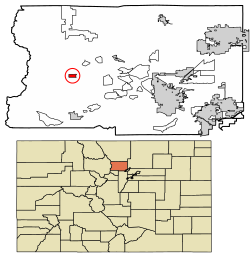
 Location of Ward in Boulder County, Colorado. | |
| Coordinates: 40°4′20″N 105°30′50″W / 40.07222°N 105.51389°W | |
| Country | |
| State | |
| County[1] | Boulder County |
| Founded | 1860 |
| Incorporated | June 9, 1896[2] |
| Government | |
| • Type | Home rule municipality[1] |
| Area | |
| • Total | 1.39 km2 (0.54 sq mi) |
| • Land | 1.39 km2 (0.54 sq mi) |
| • Water | 0.00 km2 (0.00 sq mi) |
| Elevation | 2,884 m (9,462 ft) |
| Population (2020) | |
| • Total | 128 |
| • Density | 116.08/km2 (300.37/sq mi) |
| Time zone | UTC-7 (Mountain (MST)) |
| • Summer (DST) | UTC-6 (MDT) |
| ZIP code[5] | 80481 |
| Area code | 303 |
| FIPS code | 08-82735 |
| GNIS feature ID | 2413449[4] |
| Website | www |
Ward is a home rule municipality in Boulder County, Colorado, United States. The population was 128 at the 2020 census. The town is a former mining settlement founded in 1860 in the wake of the discovery of gold at nearby Gold Hill. Once one of the richest towns in the state during the Colorado Gold Rush, it is located on a mountainside at the top of Left Hand Canyon, near the Peak to Peak Highway (State Highway 72) northwest of Boulder at an elevation of 9,450 feet (2,880 m) above sea level.
- ^ a b "Active Colorado Municipalities". State of Colorado, Department of Local Affairs. Archived from the original on December 12, 2009. Retrieved September 1, 2007.
- ^ "Colorado Municipal Incorporations". State of Colorado, Department of Personnel & Administration, Colorado State Archives. December 1, 2004. Retrieved September 2, 2007.
- ^ "2019 U.S. Gazetteer Files". United States Census Bureau. Retrieved July 1, 2020.
- ^ a b U.S. Geological Survey Geographic Names Information System: Ward, Colorado
- ^ "ZIP Code Lookup" (JavaScript/HTML). United States Postal Service. Retrieved January 8, 2008.