Ward Beach | |
|---|---|
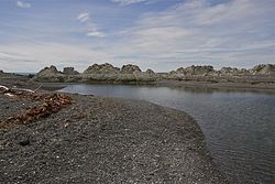
 Ward Beach, where the Flaxbourne River flows into the sea | |
| Coordinates: 41°50′42″S 174°11′00″E / 41.84500°S 174.18333°E | |
| Location | Marlborough, New Zealand |
Ward Beach is a section of rugged coastline in the Marlborough Region of New Zealand that is known for unusual rock formations. The geological features include the exposed reef platforms that were uplifted by 2 m or more during the 2016 Kaikōura earthquake, and the spherical concretions known as the Ward Beach boulders. Another formation known as the Chancet Rocks is located in a scientific reserve about 1.5 km to the north of the Ward Beach roadend. They contain unusual trace fossils and provide amongst the best on-land evidence of the Cretaceous–Paleogene boundary in marine sediments in the Southern Hemisphere.
Ward Beach has been used as a launching site by a locally based commercial crayfishing company for more than 40 years. However, the uplift of the beach caused by the 2016 earthquake prevented the company from safely launching boats from the previous location. Over a period of several years, the company has sought options that would provide a safe place to launch from the beach. Most of these options have been opposed in environmental consent hearings because of the threat to endangered species. An exclusion zone has been established from just north of the Ward Beach road end to the Chancet Rocks, to protect the area from incursion by vehicles.
