| Ward Creek | |
|---|---|
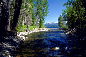
 The mouth of Ward Creek on Lake Tahoe | |
| Native name | dagásliʔ (Washo) [3] |
| Location | |
| Country | United States |
| State | California |
| Region | Placer County |
| Cities | Pine Land, Timberland |
| Physical characteristics | |
| Source | Between Ward Peak and Twin Peaks[4] in the Granite Chief Wilderness of the Sierra Nevada Mountains |
| • coordinates | 39°07′10″N 120°14′20″W / 39.11944°N 120.23889°W[2] |
| • elevation | 7,940 ft (2,420 m)[5] |
| Mouth | Lake Tahoe |
• location | Tahoe Pines |
• coordinates | 39°07′45″N 120°09′18″W / 39.12917°N 120.15500°W[2] |
• elevation | 6,234 ft (1,900 m)[2] |

Ward Creek is a 6.1-mile (9.8 km) eastward-flowing stream in Placer County, California, United States.[5] The creek flows into Lake Tahoe 2.7 miles (4.3 km) south of Tahoe City, California, and has undergone extensive restoration to reduce sediment and surface run-off to maintain the purity of Lake Tahoe.
- ^ Barbara Lekisch (1988). Tahoe Place Names: the Origin and History of Names in the Lake Tahoe Basin. Lafayette, California: Great West Books. p. 147. ISBN 978-0-944220-01-6. Retrieved June 28, 2014.
- ^ a b c d U.S. Geological Survey Geographic Names Information System: Ward Creek
- ^ "The Washo Project Online Dictionary". Retrieved May 27, 2012.
- ^ U.S. Geological Survey Geographic Names Information System: Twin Peaks
- ^ a b U.S. Geological Survey. National Hydrography Dataset high-resolution flowline data. The National Map, accessed July 16, 2013
