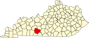
Warren County | |
|---|---|
 Warren County Justice Center in Bowling Green | |
 Location within the U.S. state of Kentucky | |
 Kentucky's location within the U.S. | |
| Coordinates: 36°59′N 86°25′W / 36.99°N 86.42°W | |
| Country | |
| State | |
| Founded | December 19, 1796 |
| Named for | Joseph Warren |
| Seat | Bowling Green |
| Largest city | Bowling Green |
| Area | |
• Total | 548 sq mi (1,420 km2) |
| • Land | 542 sq mi (1,400 km2) |
| • Water | 6.0 sq mi (16 km2) 1.1% |
| Population (2020) | |
• Total | 134,554 |
• Estimate (2023) | 142,229 |
| • Density | 250/sq mi (95/km2) |
| Time zone | UTC−6 (Central) |
| • Summer (DST) | UTC−5 (CDT) |
| Congressional district | 2nd |
| Website | www |
Warren County is a county located in the south central portion of the U.S. state of Kentucky. As of the 2020 census, the population was 134,554,[1] making it the fifth-most populous county in Kentucky. The county seat is Bowling Green.[2] Warren County is now classified as a wet county after voters approved the measure in 2018. The measure became law in January 2019 that allows alcohol to be sold county wide.[3]
Warren County is included in the Bowling Green, KY Metropolitan Statistical Area. It is located in the Pennyroyal Plateau and Western Coal Fields regions.[4]
- ^ "State & County QuickFacts". United States Census Bureau. Retrieved June 28, 2022.
- ^ "Find a County". National Association of Counties. Retrieved June 7, 2011.
- ^ "Wet & Dry Counties in Kentucky" (PDF). Kentucky Office of Alcoholic Beverage Control. Archived from the original (PDF) on March 15, 2007. Retrieved March 21, 2007.
- ^ "Warren County, Kentucky - Kentucky Atlas and Gazetteer". www.uky.edu.