| Warriewood Sydney, New South Wales | |||||||||||||||
|---|---|---|---|---|---|---|---|---|---|---|---|---|---|---|---|
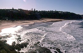
 Warriewood Beach | |||||||||||||||
 | |||||||||||||||
| Coordinates | 33°41′38″S 151°18′17″E / 33.69378°S 151.30464°E | ||||||||||||||
| Population | 8,379 (2021 census)[1] | ||||||||||||||
| • Density | 1,995/km2 (5,170/sq mi) | ||||||||||||||
| Postcode(s) | 2102 | ||||||||||||||
| Elevation | 8 m (26 ft) | ||||||||||||||
| Area | 4.2 km2 (1.6 sq mi) | ||||||||||||||
| Location | 26 km (16 mi) north of Sydney CBD | ||||||||||||||
| LGA(s) | Northern Beaches Council | ||||||||||||||
| State electorate(s) | Pittwater | ||||||||||||||
| Federal division(s) | Mackellar | ||||||||||||||
| |||||||||||||||
Warriewood is a suburb in northern Sydney, in the state of New South Wales, Australia. Warriewood is located 26 kilometres north of the Sydney central business district, in the local government area of Northern Beaches Council. Warriewood is part of the Northern Beaches region.
- ^ "Warriewood, 2021 Census All persons QuickStats". www.abs.gov.au. Australia Bureau of Statistics. Retrieved 12 September 2022.