| Warrnambool Victoria | |||||||||
|---|---|---|---|---|---|---|---|---|---|
 Warrnambool foreshore from Pickering Point | |||||||||
| Coordinates | 38°23′0″S 142°29′0″E / 38.38333°S 142.48333°E | ||||||||
| Population | 35,743 (2021)[1] | ||||||||
| Established | 1855 | ||||||||
| Postcode(s) | 3280 | ||||||||
| Time zone | AEST (UTC+10) | ||||||||
| • Summer (DST) | AEST (UTC+11) | ||||||||
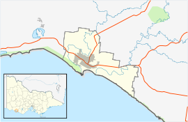
| Location | |||||||||
| LGA(s) | City of Warrnambool | ||||||||
| State electorate(s) | South-West Coast | ||||||||
| Federal division(s) | Wannon | ||||||||
| |||||||||
Warrnambool (/ˈwɔːrnəmbuːl/ ; Maar: Peetoop or Wheringkernitch or Warrnambool)[2] is a city on the south-western coast of Victoria, Australia. At the 2021 census, Warrnambool had a population of 35,743.[1] Situated on the Princes Highway, Warrnambool (Allansford) marks the western end of the Great Ocean Road and the southern end of the Hopkins Highway.
- ^ a b Australian Bureau of Statistics (28 June 2022). "Warrnambool". 2021 Census QuickStats. Retrieved 12 October 2022.
- ^ Clark, Ian D. (2002). Dictionary of Aboriginal placenames of Victoria. Heydon, Toby, 1972-, Victorian Aboriginal Corporation for Languages. Melbourne: Victorian Aboriginal Corp. for Languages. ISBN 0-9579360-2-8. OCLC 54913331.
