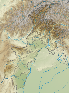
| Warsak Dam, District Mohmand | |
|---|---|
 | |
| Official name | د ورسک بند |
| Country | Pakistan |
| Location | Kabul River, District Mohmand |
| Coordinates | 34°09′50″N 71°21′29″E / 34.16389°N 71.35806°E |
| Status | Operational |
| Construction began | 1949 |
| Opening date | 1960 |
| Owner(s) | The Royalty of Warsak Dam belongs to the Public of District Mohmand |
| Dam and spillways | |
| Type of dam | Gravity |
| Impounds | Kabul River |
| Height | 76.2 m (250 ft) |
| Length | 140.2 m (460 ft) |
| Spillways | 9 floodgates |
| Spillway type | Service, controlled |
| Spillway capacity | 540 m3/s (19,070 cu ft/s) |
| Reservoir | |
| Active capacity | 31,207,090 m3 (25,300 acre⋅ft) (design, now silted) |
| Surface area | 10.3 km2 (4 sq mi) |
| Power Station | |
| Commission date | 1960, 1981 |
| Hydraulic head | 144 m (472 ft) |
| Turbines | 4 x 40 MW, 2 x 41.5 MW Francis-type |
| Installed capacity | 243 MW |
| Annual generation | 1100 GWh |

Warsak Dam (Pashto: د ورسک بند; Urdu: ورسک ڈیم) is a mass concrete gravity dam located on the Kabul River in District Mohmand, Mechni, approximately 30 km northwest from the city of Peshawar in the Khyber Pakhtunkhwa province of Pakistan.

