| Wasatch Fault | |
|---|---|
| Country | USA |
| State | Utah |
| Characteristics | |
| Segments | 10 |
| Length | 390km |
| Displacement | 0.8-1.2mm/yr |
| Tectonics | |
| Status | active |
| Earthquakes | 2020 Salt Lake City earthquake |
| Type | normal fault |


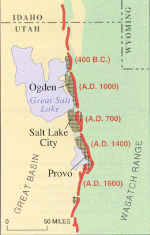
The Wasatch Fault is an active fault located primarily on the western edge of the Wasatch Mountains in the U.S. states of Utah and Idaho. The fault is about 240 miles (390 kilometres) long, stretching from southern Idaho, through northern Utah, before terminating in central Utah near the town of Fayette. The fault is made up of ten segments, five of which are considered active.[1] On average the segments are approximately 25 miles (40 kilometres) long, each of which can independently produce earthquakes as powerful as local magnitude 7.5.[2] The five active segments from north to south are called the Brigham City Fault Segment, the Weber Fault Segment, the Salt Lake City Fault Segment, the Provo Fault Segment and the Nephi Fault Segment.[citation needed]
The Wasatch Fault is a normal (vertical motion) fault which forms the eastern boundary of the Basin and Range geologic province which comprises the geographic Great Basin. The Wasatch Mountains have been uplifted and tilted to the east by movement of the fault.[3] The average vertical displacement rate of the fault over its history is approximately 0.8–1.2 mm/yr.[4]
- ^ "wasatch fault zone: Topics by Science.gov". science.gov. Retrieved 2019-02-28.
- ^ "Surficial geologic map of the Wasatch fault zone, eastern part of Utah Valley, Utah County and parts of Salt Lake and Juab counties, Utah" (PDF).
- ^ "How Big and How Frequent Are Earthquakes on the Wasatch Fault?". United States Geological Survey. Retrieved 2020-03-19.
- ^ Jewell, Paul W.; Bruhn, Ronald L. (2013). "Evaluation of Wasatch fault segmentation and slip rates using Lake Bonneville shorelines". Journal of Geophysical Research: Solid Earth. 118 (5): 2528–2543. Bibcode:2013JGRB..118.2528J. doi:10.1002/jgrb.50174.