43°42′03″N 70°17′21″W / 43.70090°N 70.28919°W
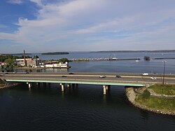
 Washington Avenue crosses Tukey's Bridge via both the northbound and southbound exit lanes | |
 | |
| Part of | |
|---|---|
| Length | 5.25 mi (8.45 km) |
| Location | Portland, Maine, U.S. |
| Northwest end | Auburn Street |
| Southeast end | Congress Street |
Washington Avenue (known colloquially as Washington Ave) is a major street in Portland, Maine, United States. It runs for around 5.25 miles (8.45 km), from Auburn Street in the northwest to Congress Street in the southeast. It continues in parallel with Interstate 295 as it crosses Tukey's Bridge between exits 8 and 9. It is the main artery for traffic entering and leaving Portland to and from the north via city streets, and has been described as a "gateway to the Portland peninsula."[1] Washington Avenue passes to the north of Back Cove, while Forest Avenue passes to its south.
Washington Avenue is part of State Route 26 for its entire course. It picks up the designation from Auburn Street, which continues as State Route 100 south of its intersection with Washington Avenue.
- ^ "Streetscape: Washington Avenue, Portland". Ransom Consulting, LLC. Retrieved 2024-05-22.