Washington County | |
|---|---|
 | |
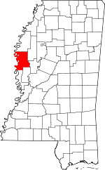
 Location within the U.S. state of Mississippi | |
 Mississippi's location within the U.S. | |
| Coordinates: 33°17′N 90°57′W / 33.29°N 90.95°W | |
| Country | |
| State | |
| Founded | 1827 |
| Named for | George Washington |
| Seat | Greenville |
| Largest city | Greenville |
| Area | |
• Total | 761 sq mi (1,970 km2) |
| • Land | 725 sq mi (1,880 km2) |
| • Water | 36 sq mi (90 km2) 4.8% |
| Population (2020) | |
• Total | 44,922 |
• Estimate (2023) | 41,946 |
| • Density | 59/sq mi (23/km2) |
| Time zone | UTC−6 (Central) |
| • Summer (DST) | UTC−5 (CDT) |
| Congressional district | 2nd |
| Website | www |
Washington County is a county located in the U.S. state of Mississippi. As of the 2020 census, the population was 44,922.[1] Its county seat is Greenville.[2] The county is named in honor of the first president of the United States, George Washington. It is located next to the Arkansas border. The Greenville, MS Micropolitan Statistical Area includes all of Washington County. It is located in the Mississippi Delta.
- ^ "Census - Geography Profile: Washington County, Mississippi". United States Census Bureau. Retrieved January 15, 2023.
- ^ "Find a County". National Association of Counties. Retrieved June 7, 2011.