36°44′50″N 95°58′50″W / 36.747206°N 95.980597°W
Washington County | |
|---|---|
 | |
 Location within the U.S. state of Oklahoma | |
 Oklahoma's location within the U.S. | |
| Coordinates: 36°44′50″N 95°58′50″W / 36.747206°N 95.980597°W | |
| Country | |
| State | |
| Founded | 1907 |
| Named for | George Washington |
| Seat | Bartlesville |
| Largest city | Bartlesville |
| Area | |
| • Total | 424 sq mi (1,100 km2) |
| • Land | 415 sq mi (1,070 km2) |
| • Water | 8.8 sq mi (23 km2) 2.1% |
| Population (2020) | |
| • Total | 52,455 |
| • Density | 120/sq mi (50/km2) |
| Congressional district | 2nd |
| Website | www |
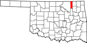
Washington County is a county located in the northeastern part of the U.S. state of Oklahoma. As of the 2020 census, the population was 52,455.[1] Its county seat is Bartlesville.[2] Named for President George Washington, it is the smallest county in Oklahoma in total area,[3] adjacent to the largest county in Oklahoma, Osage County. Washington County comprises the Bartlesville, OK micropolitan statistical area, which is also included in the Tulsa-Muskogee-Bartlesville, OK combined statistical area. It is located along the border with Kansas.
- ^ Cite error: The named reference
censuswas invoked but never defined (see the help page). - ^ "Find a County". National Association of Counties. Retrieved June 7, 2011.
- ^ Jon D. May, "Washington County." Encyclopedia of Oklahoma History and Culture.