| Washington State Park | |
|---|---|
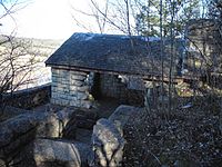
 Stone shelter overlooking the Big River valley | |
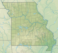
| Location | Washington County, Missouri, United States |
| Coordinates | 38°05′00″N 90°41′18″W / 38.08333°N 90.68833°W[1] |
| Area | 2,147.57 acres (8.6909 km2)[2] |
| Elevation | 673 ft (205 m)[1] |
| Established | 1932[3] |
| Visitors | 233,424 (in 2017)[4] |
| Governing body | Missouri Department of Natural Resources |
| Website | Washington State Park |
Washington State Park Petroglyph Archeological Site | |
 An eagle petroglyph at Washington State Park | |
| Nearest city | Fertile, Missouri |
| Area | 25 acres (10 ha) |
| NRHP reference No. | 70000352[5] |
| Added to NRHP | April 3, 1970 |
Washington State Park CCC Historic District | |
 Washington State Park CCC pavilion | |
| Nearest city | Potosi, Missouri |
| Area | 710 acres (290 ha) |
| Built | 1934 |
| Built by | Civilian Conservation Corps |
| Architectural style | Rustic |
| MPS | ECW Architecture in Missouri State Parks 1933-1942 TR |
| NRHP reference No. | 85000517[6] |
| Added to NRHP | March 4, 1985 |
Washington State Park is a public recreation area covering 2,147 acres (869 ha) in Washington County in the central eastern part of the state of Missouri. It is located on Highway 21 about 14 miles (23 km) northeast of Potosi or 7 miles (11 km) southwest of De Soto on the eastern edge of the Ozarks. The state park is noted for its Native American rock carvings and for its finely crafted stonework from the 1930s.[3]
- ^ a b "Washington State Park". Geographic Names Information System. United States Geological Survey, United States Department of the Interior.
- ^ Cite error: The named reference
scorpwas invoked but never defined (see the help page). - ^ a b "Washington State Park". Missouri State Parks. Missouri Department of Natural Resources. Retrieved February 6, 2013.
- ^ Cite error: The named reference
visitation2017was invoked but never defined (see the help page). - ^ "National Register Information System". National Register of Historic Places. National Park Service. July 9, 2010.
- ^ Cite error: The named reference
nominationwas invoked but never defined (see the help page).

