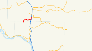
 SR 506 highlighted in red on a map of southwestern Washington. | ||||
| Route information | ||||
| Auxiliary route of I-5 | ||||
| Maintained by WSDOT | ||||
| Length | 11.53 mi[1] (18.56 km) | |||
| Existed | 1964[2]–present | |||
| Major junctions | ||||
| West end | 2nd Street in Ryderwood | |||
| East end | ||||
| Location | ||||
| Country | United States | |||
| State | Washington | |||
| Highway system | ||||
| ||||
State Route 506 (SR 506) is an 11.53-mile (18.56 km) long state highway in Cowlitz and Lewis counties, part of the U.S. state of Washington, serving the communities of Ryderwood and Vader. SR 506 begins at the intersection of 2nd and Morse Street in Ryderwood, a community in Cowlitz County, traveling north into Lewis County and turning east past Vader to parallel the Cowlitz River and interchange Interstate 5 (I-5) twice west of Toledo. Originating as Secondary State Highway 1P (SSH 1P) in 1937, the highway was designated in its current form in 1964 and it shared its eastern terminus with SR 505. SR 411 terminated at Vader and both SR 411 and SR 505 were moved away from SR 506 in 1991.
- ^ Washington State Department of Transportation (2008). "State Highway Log, 2008" (PDF). Retrieved October 31, 2009.
- ^ Washington State Legislature (1970). "RCW 47.17.665: State route No. 506". Retrieved October 31, 2009.
