| Wateree River | |
|---|---|
 Wateree River from the Palmetto Trail near Eastover, South Carolina | |
 The Wateree River | |
| Location | |
| Country | United States |
| States | South Carolina |
| Counties | Edgefield, Fairfield, Kershaw, Sumter, Richland |
| Physical characteristics | |
| Source | Catawba River |
| • location | Liberty Hill, South Carolina |
| • coordinates | 34°28′04″N 80°53′17″W / 34.46778°N 80.88806°W[1] |
| • elevation | 223 ft (68 m) |
| Mouth | Santee River |
• location | Fort Motte, South Carolina |
• coordinates | 33°44′39″N 80°37′09″W / 33.74417°N 80.61917°W[1] |
• elevation | 75 ft (23 m)[1] |
| Length | 75 mi (121 km)}[2] |
| Basin features | |
| Progression | Wateree → Santee → Atlantic Ocean |
| River system | Catawba River |
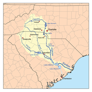
The Wateree River, about 75 mi (120 km) long, is a tributary of the Santee River in central South Carolina in the United States, which flows to the Atlantic Ocean. It was named for the Wateree Native Americans, a tribe who had migrated to this area from western North Carolina. They lived here until the early 18th century, when they were set upon and displaced by mostly English settlers during the Yamasee War. Survivors merged with the larger Catawba people, becoming extinct as a tribe.[3]
- ^ a b c "Wateree River". Geographic Names Information System. United States Geological Survey, United States Department of the Interior. June 17, 1980. Retrieved December 28, 2020.
- ^ "Wateree River". Visit Camden. Retrieved 5 June 2020.
- ^ Swanton, John Reed (1952). The Indian Tribes of North America. US Government Printing Office. p. 102. ISBN 978-0-8063-1730-4.
