Waterford, Virginia | |
|---|---|
 The Waterford town center in July 2008 | |
| Coordinates: 39°11′12″N 77°36′36″W / 39.18667°N 77.61000°W | |
| Country | |
| State | |
| County | |
| Area | |
• Total | 0.36 sq mi (0.94 km2) |
| • Land | 0.36 sq mi (0.94 km2) |
| • Water | 0.0 sq mi (0.0 km2) |
| Time zone | UTC−5 (Eastern (EST)) |
| • Summer (DST) | UTC−4 (EDT) |
| ZIP code | 20197 |
| FIPS code | 51-83440 |
| GNIS feature ID | 2807429 |
Waterford Historic District | |
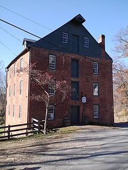
 The Waterford Mill | |
| NRHP reference No. | 69000256 |
|---|---|
| VLR No. | 401-0123 |
| Significant dates | |
| Added to NRHP | June 3, 1969[3] |
| Designated NHLD | April 15, 1970[4] |
| Designated VLR | May 13, 1969[2] |

Waterford is a unique place of historic significance. The entire village and surrounding countryside is a National Historic Landmark District, noted for its well-preserved 18th and 19th-century character. It is an unincorporated village and census-designated place (CDP) in the Catoctin Valley of Loudoun County, Virginia, located along Catoctin Creek. Waterford is 47 miles (76 km) northwest of Washington, D.C., and 7 miles (11 km) northwest of Leesburg.
In the 1810 United States Census, the population center of the United States was recorded as being just northwest of the village.[5]
- ^ "2020 U.S. Gazetteer Files –Virginia". United States Census Bureau. Archived from the original on March 18, 2021. Retrieved March 3, 2021.
- ^ "Virginia Landmarks Register". Virginia Department of Historic Resources. Archived from the original on September 21, 2013. Retrieved June 5, 2013.
- ^ "National Register Information System". National Register of Historic Places. National Park Service. January 23, 2007.
- ^ "Waterford Historic District". National Historic Landmark summary listing. National Park Service. Archived from the original on August 9, 2007. Retrieved April 21, 2008.
- ^ "2000 U.S. Population Centered in Missouri". National Atlas of the United States. April 2, 2001. Archived from the original on September 19, 2014. Retrieved September 27, 2014.


