| Waterstock | |
|---|---|
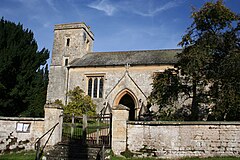
 St. Leonard's parish church | |
Location within Oxfordshire | |
| Population | 65 (2001 census)[1] |
| OS grid reference | SP6305 |
| Civil parish |
|
| District | |
| Shire county | |
| Region | |
| Country | England |
| Sovereign state | United Kingdom |
| Post town | Oxford |
| Postcode district | OX33 |
| Dialling code | 01865 |
| Police | Thames Valley |
| Fire | Oxfordshire |
| Ambulance | South Central |
| UK Parliament | |
Waterstock is a village and civil parish on the River Thame about 4.5 miles (7 km) west of the market town of Thame in Oxfordshire. The parish is bounded to the north and west by the river, to the south largely by the A418 main road, and to the east largely by the minor road between Tiddington and Ickford Bridge across the Thame. On the north side of the parish, the river forms the county boundary with Buckinghamshire as well as the parish boundary with Ickford and Worminghall. Waterstock village is on a minor road north of the A418 and is surrounded by open farming land. In the village are about 50 houses and a farm along one main street.
- ^ "Area selected: South Oxfordshire (Non-Metropolitan District)". Neighbourhood Statistics: Full Dataset View. Office for National Statistics. Retrieved 30 March 2010.
