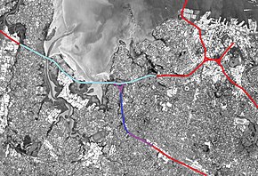
 While generally considered a "tunnel project", the Waterview Connection also included other large motorway works. The connection consists of the purple (above ground) and dark blue (bored tunnels) sections. The section of SH16 with extra lanes added is shown in light blue. | |
| Location | Auckland, New Zealand |
|---|---|
| Proposer | NZ Transport Agency |
| Project website | http://www.nzta.govt.nz/projects/waterviewconnection |
| Status | Opened 2 July 2017 |
| Type | Road & tunnel |
| Cost estimate | $1.7 billion[1] |
| Stakeholders | Government of New Zealand, NZ Transport Agency, Auckland Council, Campaign for Better Transport, Cycle Action Auckland, Friends of Oakley Creek, North West Community Association, various further community groups and submitters |
The Waterview Connection is a motorway section through west/central Auckland, New Zealand. It connects State Highway 20 in the south at Mt Roskill to State Highway 16 in the west at Point Chevalier, and is a part of the Western Ring Route.
The Waterview Connection is 4.5 km long, of which 2.5 km are in the form of twin tunnels. The Waterview Tunnel supersedes the Lyttelton Road Tunnel as New Zealand's longest road tunnels. By 2026, the link is expected to carry 83,000 vehicles a day.[1][2] There are three lanes of traffic in each tunnel.[3]
- ^ a b Cite error: The named reference
MOSTwas invoked but never defined (see the help page). - ^ Cite error: The named reference
CHIDEDwas invoked but never defined (see the help page). - ^ "Auckland's Waterview Connection on schedule to open in early 2017". Stuff.co.nz. 9 June 2016. Retrieved 15 May 2017.