Watino | |
|---|---|
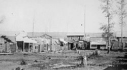
 Watino, circa 1915 | |
| Coordinates: 55°43′09″N 117°37′02″W / 55.71917°N 117.61722°W | |
| Country | Canada |
| Province | Alberta |
| Region | Northern Alberta |
| Census division | 19 |
| Municipal district | Birch Hills County |
| Government | |
| • Type | Unincorporated |
| • Governing body | Birch Hills County Council |
| Population (1991)[1] | |
| • Total | 22 |
| Time zone | UTC−07:00 (MST) |
| • Summer (DST) | UTC−06:00 (MDT) |
| Area code(s) | 780, 587, 825 |
Watino is a hamlet in northern Alberta, Canada within Birch Hills County.[2] It is located on Highway 49, approximately 96 kilometres (60 mi) northeast of Grande Prairie, and has an elevation of 385 meters (1,263 ft).
- ^ Cite error: The named reference
1991censuswas invoked but never defined (see the help page). - ^ "Specialized and Rural Municipalities and Their Communities" (PDF). Alberta Municipal Affairs. June 3, 2024. Retrieved June 14, 2024.

