| Watling Street | |
|---|---|
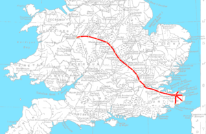
 A map of the Saxon Watling Street overlaid on the Roman road network | |
 A stretch of modern-day Watling Street in Buckinghamshire[a] | |
| Route information | |
| Length | 276 mi (444 km) [230 mi (370 km)] Rutupiae to Viroconium |
| Time period | Roman Britain Saxon Britain |
| Margary number | 1 |
| Major junctions | |
| From | The Kentish ports |
| Canterbury, London, St Albans | |
| To | Wroxeter |
| Location | |
| Country | United Kingdom |
| Road network | |
Watling Street is a historic route in England, running from Dover and London in the southeast, via St Albans to Wroxeter. The road crosses the River Thames at London and was used in Classical Antiquity, Late Antiquity, and throughout the Middle Ages. It was used by the ancient Britons and paved as one of the main Roman roads in Britannia (Roman-governed Great Britain during the Roman Empire). The line of the road was later the southwestern border of the Danelaw with Wessex and Mercia, and Watling Street was numbered as one of the major highways of medieval England.
First used by the ancient Britons, mainly between the areas of modern Canterbury and St Albans using a natural ford near Westminster, the road was later paved by the Romans. It connected the ports of Dubris (Dover), Rutupiae (Richborough Castle), Lemanis (Lympne), and Regulbium (Reculver) in Kent to the Roman bridge over the Thames at Londinium (London). The route continued northwest through Verulamium (St Albans) on its way to Viroconium Cornoviorum (Wroxeter). Watling Street is traditionally cited as having been the location of the Romans' defeat of Boudica, though precisely where on the route is disputed.
The Roman Antonine Itinerary lists sites along the route of Watling Street as part of a longer route of 500 Roman miles connecting Richborough with Hadrian's Wall via Wroxeter. The continuation on to Blatobulgium (Birrens, Dumfriesshire) beyond Hadrian's Wall in modern Scotland may have been part of the same route, leading some scholars to call this Watling Street as well, although others restrict it to the southern leg.
In the early 18th century, England's first turnpike trust was established to pave the route through Bedfordshire and Buckinghamshire. In the early 19th century, the course between London and the Channel was paved and became known as the Great Dover Road.
The route from London to Wroxeter forms much of the A5 road. The route from Dover to London forms part of the A2 road. At various points along the historic route, the name Watling Street remains in modern use.
Cite error: There are <ref group=lower-alpha> tags or {{efn}} templates on this page, but the references will not show without a {{reflist|group=lower-alpha}} template or {{notelist}} template (see the help page).