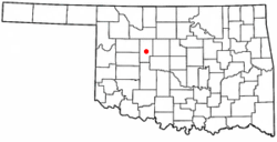
Watonga, Oklahoma | |
|---|---|
 Location of Watonga, Oklahoma | |
| Coordinates: 35°50′58″N 98°25′01″W / 35.84944°N 98.41694°W | |
| Country | United States |
| State | Oklahoma |
| County | Blaine |
| Government | |
| • Type | Aldermanic |
| Area | |
| • Total | 3.79 sq mi (9.80 km2) |
| • Land | 3.77 sq mi (9.76 km2) |
| • Water | 0.02 sq mi (0.04 km2) |
| Elevation | 1,522 ft (464 m) |
| Population (2020) | |
| • Total | 2,690 |
| • Density | 713.72/sq mi (275.57/km2) |
| Time zone | UTC-6 (Central (CST)) |
| • Summer (DST) | UTC-5 (CDT) |
| ZIP code | 73772 |
| Area code | 580 |
| FIPS code | 40-78950[3] |
| GNIS feature ID | 2412193[2] |
| Website | www |
Watonga is a city in Blaine County, Oklahoma. It is 70 miles northwest of Oklahoma City. The population was 2,690 as of the 2020 United States census.[4] It is the county seat of Blaine County.[5]
- ^ "ArcGIS REST Services Directory". United States Census Bureau. Retrieved September 20, 2022.
- ^ a b U.S. Geological Survey Geographic Names Information System: Watonga, Oklahoma
- ^ "U.S. Census website". United States Census Bureau. Retrieved January 31, 2008.
- ^ "Watonga (city), Oklahoma". United States Census Bureau. Retrieved March 16, 2024.
- ^ "Find a County". National Association of Counties. Retrieved June 7, 2011.