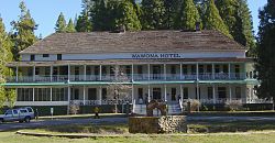
Wawona | |
|---|---|
 The Wawona Hotel | |
| Coordinates: 37°32′13″N 119°39′23″W / 37.53694°N 119.65639°W | |
| Country | |
| State | |
| County | Mariposa |
| Area | |
| • Total | 1.076 sq mi (2.79 km2) |
| • Land | 1.076 sq mi (2.79 km2) |
| • Water | 0 sq mi (0 km2) 0% |
| Elevation | 3,999 ft (1,219 m) |
| Population (2020)[3] | |
| • Total | 111 |
| • Density | 100/sq mi (40/km2) |
| Time zone | UTC-8 (Pacific (PST)) |
| • Summer (DST) | UTC-7 (PDT) |
| ZIP code | 95389 |
| Area code | 209 |
| GNIS feature IDs | 1652868,[2] 2583183[4] |
Wawona (formerly Big Tree Station,[2] Clark's Station,[2] Clarks Station,[2] Wah-wo-nah,[2] and Clark's Ranch[5]) is a census-designated place[6] in Mariposa County, California, United States.[2] The population was 111 at the 2020 census.[3]
It is located entirely within Yosemite National Park, as it preceded the founding of the park as a national recreation area. The number of inhabitants increases dramatically during peak tourist seasons, due to the large number of rental cabins in the town. It is located at 37°32′13″N 119°39′23″W / 37.53694°N 119.65639°W,[2] 20 miles (32 km) north of Oakhurst and 26 miles (42 km) south of the center of Yosemite Valley, at an elevation of 3,999 feet (1,219 m).[2]
The ZIP Code is 95389. The community is inside area code 209.
- ^ "2021 U.S. Gazetteer Files: California". United States Census Bureau. Retrieved July 27, 2022.
- ^ a b c d e f g h i "Wawona". Geographic Names Information System. United States Geological Survey, United States Department of the Interior.
- ^ a b "P1. Race – Wawona CDP, California: 2020 DEC Redistricting Data (PL 94-171)". U.S. Census Bureau. Retrieved July 27, 2022.
- ^ U.S. Geological Survey Geographic Names Information System: Wawona Census Designated Place
- ^ Durham, David L. (1998). California's Geographic Names: A Gazetteer of Historic and Modern Names of the State. Clovis, Calif.: Word Dancer Press. p. 844. ISBN 1-884995-14-4.
- ^ U.S. Geological Survey Geographic Names Information System: Wawona, California

