Waynesboro, Pennsylvania | |
|---|---|
Borough | |
 | |
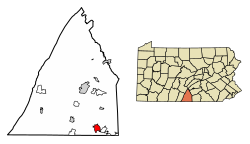
 Location of Waynesboro in Franklin County, Pennsylvania | |
| Coordinates: 39°44′56″N 77°34′53″W / 39.74889°N 77.58139°W | |
| Country | United States |
| State | Pennsylvania |
| County | Franklin |
| Settled | 1749 |
| Government | |
| • Type | Borough Council |
| • Mayor | Richard Starliper[citation needed] |
| Area | |
• Total | 3.41 sq mi (8.84 km2) |
| • Land | 3.41 sq mi (8.84 km2) |
| • Water | 0.00 sq mi (0.00 km2) |
| Elevation | 719 ft (219 m) |
| Population (2020) | |
• Total | 10,951 |
| • Density | 3,190.50/sq mi (1,231.92/km2) |
| Time zone | UTC−5 (Eastern (EST)) |
| • Summer (DST) | UTC−4 (EDT) |
| ZIP code | 17268 |
| Area code(s) | 717, 223 |
| FIPS code | 42-81824 |
| GNIS feature ID | 1215248[2] |
| Website | Waynesboro |
Waynesboro (/ˈweɪnzbʌroʊ/) is a borough in Franklin County, Pennsylvania, United States. Located on the southern border of the state, Waynesboro is in the Cumberland Valley between Hagerstown, Maryland, and Chambersburg, Pennsylvania. It is part of Chambersburg, PA Micropolitan Statistical Area, which is part of the Washington–Baltimore metropolitan area. It is two miles north of the Mason–Dixon line and close to Camp David and the Raven Rock Mountain Complex.
The population within the borough limits was 10,951 at the 2020 census.[3] When combined with the surrounding Washington and Quincy Townships, the population of greater Waynesboro is 31,166. The Waynesboro Area School District serves a resident population of 32,386, according to 2010 federal census data.
- ^ "2019 U.S. Gazetteer Files". United States Census Bureau. Retrieved July 28, 2020.
- ^ a b U.S. Geological Survey Geographic Names Information System: Waynesboro, Pennsylvania
- ^ "Explore Census Data".

